American Red Cross

Weather & Hazard Center


Red Cross Catalogs & Resources:

Home

Map Catalog

Weather & Hazard Center

Tropical Hazard Center

National Level Map Catalog

Map Services Catalog

Weather Calulators

RC View Enterprise Mapping Portal
(Restricted access)

Org Online Mapping Portal
(ArcGIS Online Org Map Center)


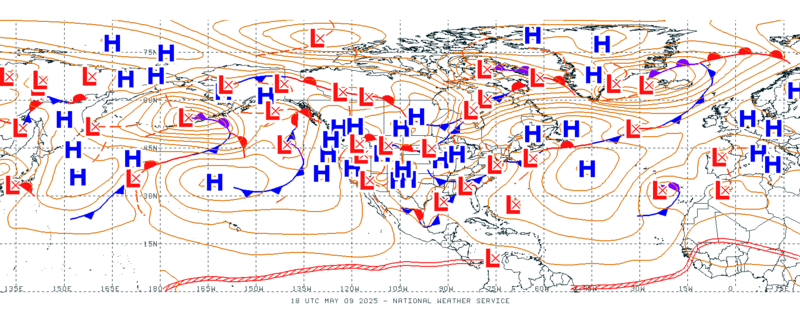
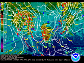
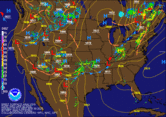
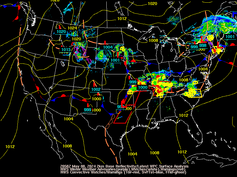
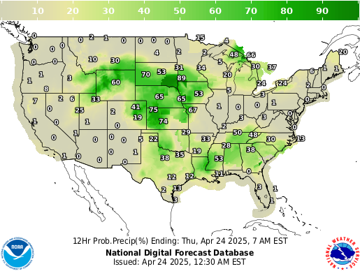
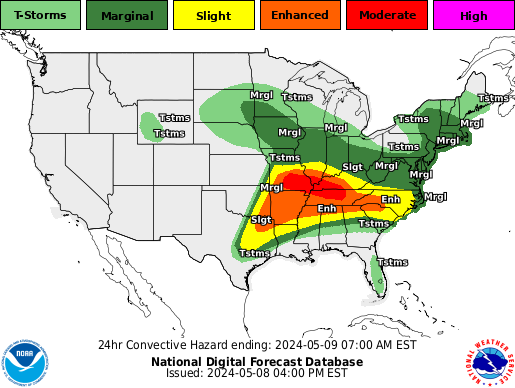
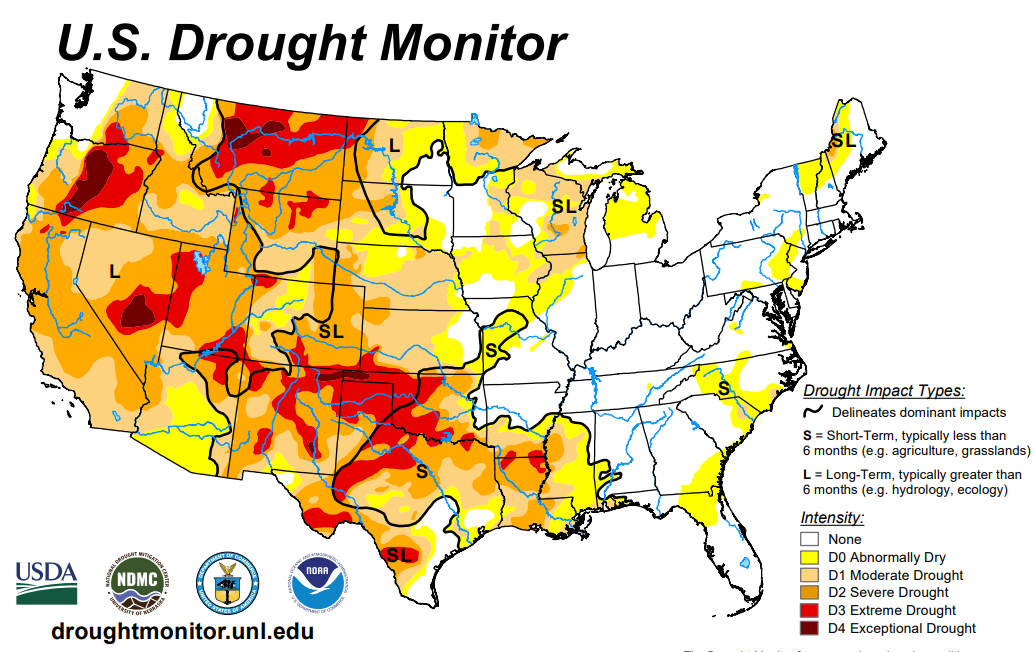
NWS - Weather Products by State

NWS - Warnings by State

NWS - "Weather Story" by WFO Grouped by NWS Region

NWS Social Media:
NWS Social Media by WFO
  NWS on Facebook

  NWS on YouTube

NWS - Local Weather Forecast by Zip Code or "City, St."
  
NOAA Local Weather Widget
La Niña / El Niño

El Niño/ENSO Basics
El Niño/ENSO Impacts
El Niño/ENSO FAQ

Current & Forecast Weather
Surface Observations
Today's Forecast
NOAA - Current Surface Observations
12 Hours |  24 Hours |  36 Hours |  48 Hours
Day 3 |  Day 4 |  Day 5 |  Day 6
NOAA - Short Range Forecast Loop
NOAA - 7 Day Forecast Loop
NOAA - Map Legend
Surface Weahter Charts
NOAA - Surface Weather Charts
NOAA - CONUS Surface Weather
Day 3 |  Day 4 |  Day 5 |  Day 6 |  Day 7
NOAA - 7 Day Surface Pressure/Fronts (Loop)
NOAA - Surface Weather Manual
Today's Forecast
NOAA - Current Surface Analysis Loop
Surface Weahter Charts
NOAA - Current Surface Analysis w/ RADAR Loop
Watches & Warnings
Warnings & Forecasts Graphical Forecasts National Maps Radar Rivers Air Quality Satellite Climate
NOAA - Active Watches, Warnings & Advisories by WFO
IWIN watches, warnings, statements and advisories issued by State
NOAA - Active Watches, Warnings & Advisories by State
Surface Lows
Operational Significant Event Imagery
NOAA - Current Surface Low Positions
Operational Significant Event Imagery
NOAA - Forecast Surface Low Positions
Temperature
Composite RADAR
NOAA - Maximum Daytime Temperature
Day 3 |  Day 4 |  Day 5 |  Day 6 |  Day 7
Alaska |  Hawaii |  Guam |  Puerto Rico
Operational Significant Event Imagery
NOAA - Minimum Overnight Temperature
Day 3 |  Day 4 |  Day 5 |  Day 6 |  Day 7
Alaska |  Hawaii |  Guam |  Puerto Rico
Precipitation
Composite RADAR
NOAA - Chance of Precipitation
Day 3 |  Day 4 |  Day 5 |  Day 6 |  Day 7
Alaska |  Hawaii |  Guam |  Puerto Rico
Operational Significant Event Imagery
NOAA - Precipitation Amount
Alaska |  Hawaii |  Guam |  Puerto Rico
Other Weather
Composite RADAR
NOAA - Predominant Weather
Alaska |  Hawaii |  Guam |  Puerto Rico
Operational Significant Event Imagery
NOAA - Wind Speed & Direction
Alaska |  Hawaii |  Guam |  Puerto Rico
Satellites
Goes IR CONUS
NOAA - GOES IR Satellite - CONUS
GOES Visible CONUS
NOAA - GOES Visible Satellite - CONUS
Hawaii IR
NOAA - GOES Satellite - Hawaii
Alaska IR
NOAA - GOES Satellite - Alaska
Puerto Rico R CONUS
NOAA - GOES Satellite - Puerto Rico
Goes West
NOAA - GOES West Satellite - Full Disk
Goes East
NOAA - GOES East Satellite - Full Disk
RADAR
Goes East
Full Screen - NOAA - NWS RADAR

NOAA - NWS New RADAR Webpage (RIDGE 2) Frequently Asked Questions
NOAA - Additional Forecast Products:
Travelers Forecast |  Enhanced Forecast/Outlook |  Short Term Forecast |  Special Weather Statement
Short Range Forecasts |  Medium Range Forecasts |  Daily Weather Map


Weather Outlooks
Day 3 - 7 U.S. Hazards Outlook
NOAA - Day 3 - 7 U.S. Hazards Outlook
Composite RADAR
NOAA - 6 - 10 Day Temperature Outlook
Operational Significant Event Imagery
NOAA - 6 - 10 Day Precipitation Outlook
Day 3 - 7 U.S. Hazards Outlook
NOAA - Day 8 - 14 U.S. Hazards Outlook
Composite RADAR
NOAA - 8 - 14 Day Temperature Outlook
Operational Significant Event Imagery
NOAA -8 - 14 Day Precipitation Outlook
NOAA - Additional Outlook Products:
One Month Outlook | U.S. Hazards Outlook | Climate Prediction Center Outlooks


Winter Weather
Snowfall Probablility Forecasts
Day 1 - Greater then 1 inch
Day 1 - Snowfall Greater then 1 inch
Day 2 -Greater then 1 inch
Day 2 - Snowfall Greater then 1 inch
Day 3 -Greater then 1 inch
Day 3 - Snowfall Greater then 1 inch
Day 1 - 4 inches
Day 1 - Snowfall Exceeding 4 In.
Day 2 - 4 inches
Day 2 - Snowfall Exceeding 4 In.
Day 3 - 4 inches
Day 3 - Snowfall Exceeding 4 In.
Day 1 - 8 inches
Day 1 - Snowfall Exceeding 8 In.
Day 2 - 8 inches
Day 2 - Snowfall Exceeding 8 In.
Day 3 - 8 inches
Day 3 - Snowfall Exceeding 8 In.
Day 1 - 12 inches
Day 1 - Snowfall Exceeding 12 In.
Day 2 - 12 inches
Day 2 - Snowfall Exceeding 12 In.
Day 3 - 12 inches
Day 3 - Snowfall Exceeding 12 In.
Freezing Rain Probablility Forecasts
Day 1 - Freezing Rain Greater then 0.01 inch
Day 1 - Freezing Rain Greater 0.01 inch
Day 2 -Freezing Rain Greater then 0.01 inch
Day 2 - Freezing Rain Greater 0.01 inchh
Day 3 -Freezing Rain Greater then 0.01 inch
Day 3 - Freezing Rain Greater 0.01 inch
Day 3 - 4 inches
Day 1 - Freezing Rain Exceeding .25 In.
Day 3 - 8 inches
Day 2 - Freezing Rain Exceeding .25 In.
Day 3 - 12 inches
Day 3 - Freezing Rain Exceeding .25 In.
Ice Accumulation Probablility Forecasts
Day 1 - Ice Accumulation of 0.25 inch
Day 1 - Ice Accumulation 0.25 in.
Day 2 - Ice Accumulation of 0.25 inch
Day 2 - Ice Accumulation 0.25 in
Day 3 - Ice Accumulation of 0.25 inch
Day 3 - Ice Accumulation 0.25 in
Other Winter Forecasts
Current Snow Cover
NOAA - Current Snow Cover
Day 1 - 8 inches
NOAA - Wind Chill Outlook
NOAA - Additional Winter Weather Products:
Winter Storm Summaries |  Recent Snowfall and Snowdepth Maps |  Daily Snow Cover Analysis
Snow Cover - 31 Day Loop |  Windchill Chart


Severe Weather
Current Severe Weather
Current Convective Watches
NOAA - Current Convective Watch
Today's severe weather outlook
NOAA - Today's Severe Weather Outlook
Current Convective Watches
NOAA - Thunderstorm Outlook
Today's  Mesoscale Discussion
NOAA - Current Mesoscale Discussion
Storm Reports
Today's storm reports received in the past 3 hours
NOAA - Today's Storm Reports (last 3 hours)
Today's storm reports since 6am
NOAA - Today's Storm Reports (since 6AM CST/7AM CDT)
Convective Outlooks
One Day Outlook
NOAA - Day 1 Convective Outlook
Two Day Outlook
NOAA - Day 2 Convective Outlook
Three Day Outlook
NOAA - Day 3 Convective Outlook
Five Day Outlook
NOAA - Day 4 - 8 Convective Outlook
NOAA - Additional Severe Weather Products:
Yesterday's Storm Reports |  Local Storm Reports |  Additional QPF's
Tornado Warnings |  Severe Thunderstorm Warnings
Public Severe Weather Outlook |  Severe Weather Statement |  Hazarous Weather Outlook
U.S. Tornado Enviornment Browser


Floods
Current Flood Information
Significant River Flood Outlook
NOAA - Significant River Flood Outlook
WaterWatch -- Current High Flow Conditions
USGS - Flood and High Flow Conditions
National Weather Service -- Rivers
NOAA - Advanced Hydrologic Prediction Service (AHPS)
WaterWatch -- Current Water Resource Conditions
USGS - Real Time Water Data
Quantitative Precipitation Forecasts (QPF)
Day 1 QPF
NOAA - Day One Rainfall Forecast (QPF)
Day 2 QPF
NOAA - Day Two Rainfall Forecast (QPF)
Day 3 QPF
NOAA - Day Three Rainfall Forecast (QPF)
Day 3 QPF
NOAA - 5 - Day Rainfall Forecast (QPF)
Rainfall
NOAA Excessive Rainfall Potential
NOAA - Excessive Rainfall Potential
Daily Rainfall Accumulation
NOAA - Daily Rainfall Accumulation
CoCoRaHS - Daily Precipitation
Drought Information
Below normal 7-day average streamflow
USGS - Below normal 7-day average streamflow
US Drought Monitor
The above graphic is a static representation of the US Drought Monitor
USDA - U.S. Drought Monitor
NOAA - Additional Flood Outlook Products:
Excessive Rainfall Discussion |  Flood Summary |  Flash Flood Warnings |  Flood Warnings
Probabilistic Precipitation Guidance |  Hydrologic Outlook |  Hydrometeorological Discussion


Wildfires
Fire Weather Forecasts
NOAA - Day 1 Fire Weather Outlook
WaterWatch -- Current water resources conditions
NOAA - Day 1 Fire Weather Analysis
Fire Weather Forecasts
NOAA - Day 2 Fire Weather Outlook
WaterWatch -- Current water resources conditions
NOAA - Day 3 - 8 Fire Weather Outlook
NOAA - Additional Wildfire Products:
Fire Weather |  Fire Dange Indices |  Fire Weather Notification |  Fire Weather Observations |  Fire Weather Spot Reports


Earthquakes
Recent Earthquakes
USGS - Recent Earthquakes
Did You Feel It?
USGS - Did You Feel It?
NOAA - Additional Earthquake Products:
USGS - PAGER
Earthquake Reports


Tsunami
Pacific Tsunami Warning Center
NOAA - National Tsunami Warning Center
NOAA - Additional Tsumani Products:
Tsumani Warnings | West Coast & Alaska Tsunami Warning Center


Climate & Air Quality
Drought Information
US Drought Monitor
The above graphic is a static representation of the US Drought Monitor
USDA - U.S. Drought Monitor
The Latest Seasonal Outlook
NOAA - U.S. Seasonal Drought Outlook
Keetch-Byram Drought Index
WFAS - Keetch-Byram Drought Index
Palmer Drought Severity Index
NOAA - Palmer Drought Severity Index
UV Information
NOAA Experimental UV Alert Forecast Map
EPA - UV Alert Forecast Map
Current UV Index
EPA - Current UV Index
Air Quality & Heat
National Outlook for Air Quality
Air Quality Forecast
Daily Maximum Heat Index Maps
NOAA - Heat Index Chart | Daily Maximums
Upper Atmosphere
Total Ozone
NASA - Total Ozone
Additional Climate Products:
NOAA Air Quality |  Air Quality Weather Summary |  Air Quality Graphic Forecasts
Today's UV Forecast Map |  UV Alert Forecast Map |  Heat Index Forecasts
National Integrated Drought Information System
Additional Weather & Hazard Resources:
General Weather
National Weather Service (NWS) - Main Weather Page
NWS - Graphical Forecasts
NWS - Weather & Hazards Data Viewer
NWS - Enhanced Data Display
NWS - nowCOAST Data Display
NOAA Daily Briefing
NOAA Daily Forecast Discussion
NWS Weather Prediction Center (WPC)
The Weather Channel - General Weather
NOAA Weather Radio
NWS - Weather Centers

General Weather Maps
Interactive Web APP
Interactive Web MAP

Severe Weather
NWS - Storm Prediction Center (SPC)
NWS/SPC - Convective Outlooks
NWS/SPC - Severe Storm Reports
Severe Weather Hazard Mapping
Floods
NWS - Weather Prediction Center (WPC) - Flood Outlook
NWS/WPC - Quantitative Precipitation Forecast (QPF)
NWS/WPC - Excessive Rainfall Forecast
USACE - River Gauges
EPA - Surf Your Watershed
Dartmouth - Flood Observatory
NOAA - CoCoRaHS Rain Network
NWS - Advanced Hydrologic Prediction Service (AHPS)
NWS - AHPS by State

NWS - AHPS by WFO

NWS - AHPS by RFC

NWS - AHPS by Water Region

NWS - River Forecast Centers

Flood Hazard Mapping
Tropical Weather
Tropical Map and Graphic Links
Hurricane Hazard Mapping
Wildfires
National Interagency Fire Center (NIFC)
National Incident Information System
NIFC - National Interagency Coordination Center
NIFC - Current Wildland Fire Information
NIFC - Predictive Services
U.S. Forest Service - Wildland Fire Assessment System
Cal Fire
Wildfire Hazard Mapping
Earthquakes
USGS - National Earthquake Information Center
USGS - Earthquake Maps
USGS - Earthquake Hazards Program
USGS - PAGER
Incorporated Research Institutions for Seismology - Seismic Monitor
Central United States Earthquake Consortium (CUSEC)
Earthquake Hazard Mapping
Tsumani
PTWC - Pacific Ocean
NOAA - Pacific Marine Environmental Laboratory (PMEL) - Tsunami Research
International Tsunami Info Center
Tsunami Hazard Mapping
Landslides
USGS - Landslide Hazards
Landslide Hazard Mapping
Winter Weather
NWS - Winter Weather Forecasts
National Snow & Ice Data Center
NWS - National Snow Analysis
USDA - Western U.S. Snow Data
Excessive Heat
NWS/wpc - Excessive Heat Index
Volcanoes
USGS - U.S. Volcano Hazards Program
USGS - Cascades Volcano Observatory
USGS/Smithsonian Institute - Global Volcanism Program
Anchorage Volcanic Ash Reports
Washington Volcanic Ash Reports
Volcano Hazard Mapping
Avalanche
U.S. & Canada Avalanche Forecasts
U.S. Forest Service - National Avalanche Center
Avalanche & Weather Conditions
HazMat
Nuclear Regulatory Commission
U.S. Department of Transportation (USDOT) - Office of HazMat Safety
USDOT - Emergency Response Guidebook (HazMat)
Centers for Disease Control (CDC) - Emergency Preparedness
Health & Human Services (HHS) - Disaster & Emergency Resources
EPA - Environmental Response Team
NOAA - Office of Response & Restoration
Chemtrec
Tides, Oceans & Lakes
NWS Climate Prediction Center - Atlantic Sea Surface Temps
NOAA - National Buoy Data
NOAA - Water Level & Tides
NOAA - Great Lakes Coast Watch
NOS Water Level Observation Network
Climate
NOAA U.S. Drought Monitor
Climate Prediction Center
Air Quality
Air Quality Weather Summary
Air Quality Graphic Forecasts
Space Weather
NOAA - Space Weather Alerts
NOAA - Space Weather Now
NOAA - Today's Space Weather
El Niño/Southern Oscillation (ENSO)
ENSO Current Conditions
ENSO Advisories
Today's El Niño/La Niña Information
El Niño Information
International Weather
Center for Ocean-Land Atmosphere Studies - International Weather
U.N. World Meteorological Organization (WMO)
U.N. WMO - Severe World Weather
Global Disaster Alert and Coordination System (GDACS)
Asian Disaster Reduction Center (ADRC)
Weather.Org - World Weather
Publications/Education
NCEP Newsletter
NOAA AWARE Newsletter
NOAA Weather Brochures
Jetstream Weather School
NOAA Glossary
NOAA Library